MOUNTAINS + MOLEHILLS
  • Blog
  • About
  • Our People
  • Contact

a Sonoma Land Trust stewardship blog

Mountains + Molehills focuses on the adventures of the Sonoma Land Trust stewardship crew, and the day-to-day challenges and blessings that they face. The daily schedule of each crew member may involve working with power shovels, connecting with landowners, hiking around the Sonoma Valley Wildlife Corridor, building habitat for burrowing owls, avoiding skunks, trooping through poison oak, and so much more. Every day is an adventure, and we hope to share those adventures with you!
maps as tools; maps as storytellers

1/15/2016

1 Comment


by Joe Kinyon

We live in a universe defined by the dimensions of time and space — everything has its time and place. Being at the right place at the right time is a fundamental aspiration of Sonoma Land Trust. We can’t go backward in time to protect a place and we can’t go forward: We can only take action in the present or prepare for choice opportunities ahead of us. We have staff, board, partners and members who enrich our understanding so that our sense of urgency and timing to conserve a place are well informed.

I am focusing on the concept of time in order to emphasize one important relationship to time and place that underlies all that Sonoma Land Trust does. We make our decisions based upon the best information, available resources and appropriate conservation tools in order to “protect the land forever.” We can decide what will happen to the land for eternity.

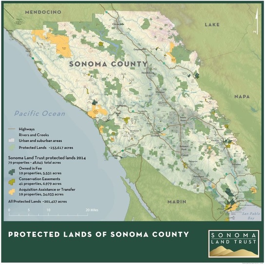
​There is a detailed story behind each of our actions to conserve our open spaces. Part of the story behind “when” we act is always “where.” Maps and Geographic Information Systems (GIS) are the tools we use to understand and communicate the “where” about a place. We use them when we plan to protect it, when we protect it and when we embark on the daily task of ongoing stewardship.

We use our five senses to navigate the world, but there is a sixth sense (not the paranormal sort) that we use daily. The writer Rebecca Solnit summarized it neatly: “Sense of place is the sixth sense, an internal compass and map made by memory and spatial perception together.” Our organization’s internal compass must be robust as we need it to strategize and prioritize our conservation projects. We must be well read in the geography of Sonoma County, we must be geographically literate, we must understand the spatial relationships of people, agriculture and ecology that need to be tended, and we need to be able to read and write the stories of geography.

Sonoma Land Trust consumes maps. On an ongoing basis, they are at our side as we engage, drive, hike, stroll, explain and orient to our place in Sonoma County. We benefit from the many agencies and partners that communicate their expertise through maps and share their computer mapping information. The Sonoma Vegetation Mapping and LIDAR Program is just one example of the resources we use in our work. By overlaying their maps and information on our areas of interest, we can visualize relationships we wouldn’t be able to see on our own.

Sonoma Land Trust builds maps. Sometimes the information we need isn’t on a map yet. It may be new or has finally been observed by an expert who is capable of seeing or communicating a pattern or detail at that scale. Also, remote sensing technology may have revealed what we couldn’t see before. We often need to create new maps based on new observations and expertise. Going out with a GPS and a rancher to inspect and map the location and condition of existing fences is an essential task to understand the upcoming and ongoing cost of agricultural and natural resource conservation. Knowing this helps budget for the materials and labor for prioritized sections of fence by quickly measuring those sections highlighted for repair. A map made with this GPS-collected data and ranching expertise acts as a to-do list that keeps farm animals safe while improving sensitive riparian areas or erosion problems through maintenance of involved fences.
​
Cultural and vegetation experts show us where important sites are, where rare plants are or where transitions of habitat begin and end. With this information, we know where to act (or not act) when we clear vegetation as part of best fire management practices in coordination with our neighbors.  Maps of old logging roads may be hard to understand or orient because 50 years of vegetation have grown over them. New vegetation may obscure objects on the ground in aerial photos. Because remote sensing technologies like LIDAR can peek below the canopy, it can leverage the older road data to see where a new trail might best follow or if there are erosion problems to anticipate. Mapping is a bit like interpretation: We need to translate between disciplines, history and dialects to form a complete story.

Sometimes things aren’t on maps because they don’t exist yet — but we’d like them to. The recent levee break at Sears Point Ranch is an example of this. We needed maps of what we wanted the Sears Point Ranch tidal marsh restoration area to look like and how we wanted the ecological or hydrological relationships to function when the influence of tide water returned. We started with maps of the historic bay edge before dikes and levees “reclaimed” the marsh for agriculture, and from those, we created maps of what was there, with whom we needed to collaborate, how sea level correlated with highways and railways through Sears Point, where to bring equipment and where to dig. We visualized what we envisioned and created instructions of where and when we needed to act to make it the restoration happen.

Sometimes, what we need to know is on a map but we need to confirm or better understand what it means. Recently, a group of experts made a very informative model of the relationship of wildlife and habitat in the Sonoma Valley Wildlife Corridor. From this, they developed a map that combined data on road-less land, water and vegetation for food or cover — in short, where it is just right for wildlife. Based upon where humans are occupying the valley with homes, farms, vineyards or roads, this map illustrates the least risk to wild animals moving across the landscape. Also, we wanted more observations of where animals were moving through the valley to understand which species might benefit from protecting the area. To do this, we planned out the locations for an array of about 50 camera traps that recently wrapped up two years of observations of animal activity in Sonoma Valley. These observations have reinforced our view of that section of the county as a corridor of open space for wildlife.

We use maps and GIS to enhance our sense of place. We use them to strategize and prioritize protection to steward the lands that we have protected. We use computer maps and GIS to store the information we have learned and to illustrate the final destination and the path of changes we need to follow to restore or transform the land. All of these uses include our most consistent use of maps — storytelling. When you need to tell a story about place, maps are the prop of choice to tell or enhance the story.
Picture

​As GIS Manager, I coordinate the needs of people to communicate about place with the hardware, software, methods and data that fill those needs. The use of maps to inform our sense of place and tell our story is a function or our work that I am proud to support. Our staff makes and uses maps daily to protect Sonoma County. Your support for our organization makes this possible, so thank you. With your help, we were recently once again 
at the right place at the right time. ​
1 Comment
Joseph link
1/29/2016 02:37:35 pm

Came across this important article that includes the whole industry
5 forces catapulting geography onto the world stage

http://www.directionsmag.com/entry/five-forces-catapulting-geography-onto-the-world-stage/461863

Reply


Leave a Reply.

    about us

    Sonoma Land Trust is a local nonprofit based in Santa Rosa, CA, that conserves scenic, natural, agricultural and open lands in Sonoma County for the benefit of the community and future generations. This blog focuses on SLT's stewardship team, whose members do hands-on work to directly protect, restore, and safeguard the land for generations to come.

    subscribe to our mailing list

    * indicates required
    Give Now

    archives

    March 2019
    February 2019
    January 2019
    December 2018
    November 2018
    October 2018
    September 2018
    August 2018
    July 2018
    June 2018
    May 2018
    April 2018
    March 2018
    February 2018
    January 2018
    December 2017
    November 2017
    October 2017
    September 2017
    August 2017
    July 2017
    June 2017
    May 2017
    April 2017
    March 2017
    February 2017
    January 2017
    December 2016
    November 2016
    October 2016
    September 2016
    August 2016
    July 2016
    June 2016
    May 2016
    April 2016
    March 2016
    February 2016
    January 2016
    December 2015
    November 2015
    October 2015

    categories

    All

Powered by Create your own unique website with customizable templates.
  • Blog
  • About
  • Our People
  • Contact